
We had heard about the trails at Harpers Ferry, WV, and always wanted to go there so when we saw the weather hitting 70 degrees in March and no rain, we knew this was the perfect day to go.
For anyone wanting to do this trail, we would recommend wearing hiking boots, taking a lunch, plenty of water (the water bladders are a great option for this), and if stability is an issue, walking sticks are a good idea.
Harpers Ferry is only about an hour outside DC, and a very pleasant drive on 270N. We navigated to the Harpers Ferry National Historical Park on the West Virginia side, which was nice since it had bathroom facilities and water fountains to use before we went on the hike. The parking fee was $15 per car, and even though the park is a little ways from downtown, there was a free shuttle bus that dropped us right in the lower downtown area.

Once the bus dropped us off, we walked along the river toward the town, and you could easily see the footbridge that went along the train bridge.

The foot bridge had stairs on both sides. You could carry a bicycle up the stairs and across, but people with accessibility needs could find it difficult. Once you were on the bridge, it did give you a beautiful view of the Potomac River as you crossed into the Maryland side. One note, the footbridge is actually part of the famous Appalachian Trail.

All along the footbridge were a lot of locks with dates/names on them. It looks like this is turning into a love lock bridge. Doing some further reading, the National Park Service discourages this practice due to the weight they collectively add to the bridge, and they will remove the locks. This has caused some couples to put their locks as high or out of reach as possible to avoid their removal.

Water sports are very popular in the area. While walking over the bridge, we could see brightly colored kayaks and other boats.

Toward the end of the footbridge (on the Maryland side), we could see the train tunnel through the rocks.

Once we were over the footbridge, we turned to walk along the Chesapeake and Ohio Canal Towpath that is next the Potomac River. This part of the trail has a lot of bike riders, dog walkers and and is easy and flat.

We kept walking until we saw the bridge with the trail sign for Maryland Heights Trail marked. We walked over the bridge and crossed the 2-lane road to start the beginning of the Maryland Heights Trail. One warning: This will be the last flat part of the trail.

The trail is well marked and well groomed, but this photo is a little deceptive. The trail is an incline until you break off to the overlook – about a mile. It is not a steep incline, just a relentless uphill climb. This warning is not to discourage anyone, but just to realize that if going uphill is difficult for you, allow some extra time to get up the trail.
The is a small loop that happens before the trail splits into two separate trails. The trail on the left is a little longer but less steep. The trail on the right has some nice views, but is steeper and shorter. Both trails merge back into the main Maryland Heights Trail.

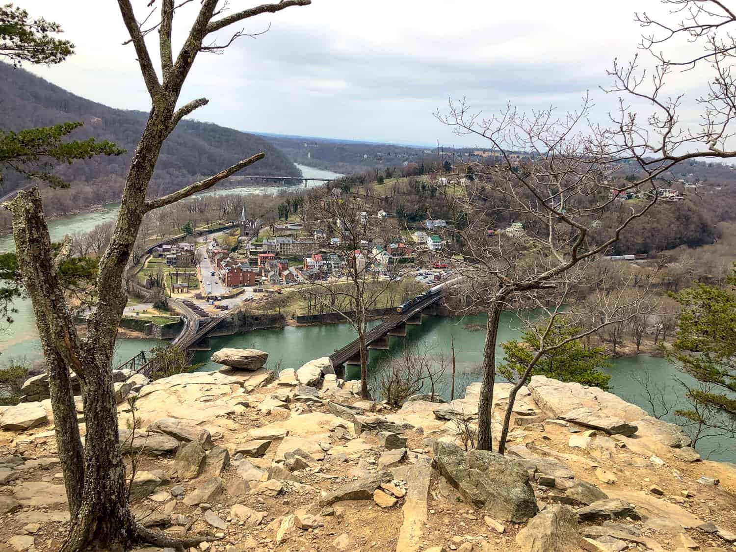
After about a mile in the trail, we came to the trail split. One trail is the Overlook Cliff Trail, and the other is the Stone Fort Trail. The Overlook Cliff Trail is a scenic overlook of the town of Harpers Ferry and is a shorter (about 1.4 miles (2.25 km) round trip from this point), easier trail. The Stone Fort Trail is a strenuous and longer trail – about 3.3 miles (5.31 km) round trip from this point – that goes up to the Fort at the top.
Since we had to be back to the town in time to get the last shuttle (at 5:15pm) and we wanted to walk around the town some, we decided to do the Overlook Cliff Trail and come back another time for the Stone Fort Trail.

The trail continues uphill for a bit and then starts to descend towards the Overlook. The Overlook views of the town and river were amazing. While the leaves were not on the trees yet, it still was a worthwhile trip. We would love to come back when the leaves are changing in the fall – that would be absolutely beautiful.
This is a great place to stop for lunch – there are many rocks that make a good sitting point.


Once we started going back down the trail, we noticed really pretty parts of the trail scenery. Towards the end back by the road, the trail follows a stream with multiple little waterfalls and pools.

Harpers Ferry Town
We crossed back over the footbridge and started to explore the town. It was a very cute town and had a lot of small museums and demonstrations of activities in the Civil War times.

A very popular option was to get ice cream on the warm day. On Potomac St, there were several shops that were offering ice cream, and the lines were very long. We decided to explore one street over on High St and found ice cream at some of the shops/delis, and there were no lines. The ice cream was a nice break after the hike.

We continued to explore the town, and it was a fun end to a beautiful hike and gorgeous weather.

Activity Level
This hike was so much fun and just difficult enough to give a great workout and made the view even more rewarding. Just for a frame of reference, here is my fitness stats for the hike (starting from the bus drop off) including the 72 equivalent flights of stairs climbed. It took us about 3 hours to do the hike (including a nice break stop at the overlook) and walk around the town.


